Settlement Study: Orchha (Madhya Pradesh)
Culture and type
Introduction:
Orchha is a fairly big town, near the City of Nirwari in Nirwari District of Madhya Pradesh. It is situated on the Betwa River, about 11 km southeast of Jhansi in the state of Uttar Pradesh. Surrounded by a thick jungle that long made it impregnable, the town was founded in 1531 and served until 1783 as the capital of Orchha princely state. The town encompasses a very dense collection of historical buildings, gardens, and traditional housing. Our group was studying the urban housing stretch adjacent to the Ram Raja Temple along the road edge.
Urban Housing stretch:


The urban housing stretch is situated along the east-west axis of Orchha which is a hybrid of various infrastructures like hospitals, schools, houses, local shops, homestays, etc. The entire stretch is a busy, vehicular road with a huge influx of people mainly due to the shops aligning either sides of the street as well as the Ram Raja Mandir being a landmark for the stretch. People occupy the food stalls/shops as spaces of rest. Many rickshaws are parked at the junction for transportation making it a very human-active space.
As we move further down the stretch, older houses start coming up. The houses follow a certain typology in which courtyards become a core organizing element.
Before we enter the house, there is a huge buffer space in the form of a raised plinth between the road and the house. This space creates affordances for people walking down the road as well as for the people inhabiting the house. This space is often used for parking the owner’s vehicles, it acts as a space for seating as well as to carry out businesses. The main gate of the house then opens up to a bigger courtyard which is open to the sky and has rooms organized around its edges.
The courtyard acts as a space for everyday chores as well as a place for worship, festivals and daily rituals. Despite it being open to sky, it provides a sense of security from the outside world. It acts as a centre for all the rooms around it. The rooms themselves are a few steps above the ground level with no furniture on the inside, there are provisions for niches in the thick walls. The rooms consist of minimum furniture. In one of the houses we studied, one of the rooms opened up to a bigger open space which was used as a kitchen for their family business. The houses formed a series of open and closed spaces while still having a sense of privacy and security.
The difference between the older houses and newly renovated houses is quite apparent by looking at the plinths, railings, terraces and building material. The newer houses have less interaction with the street hence having less affordances. They have stilt parking inside their property.
As we start moving further down the stretch, the plinths start getting higher but the interaction and the affordances start getting lesser. The houses further down follow a certain typology where the shops and the houses coexist in a single block. The houses started comprising of long passages opening into courtyards where they carry out their daily chores.
The houses start using more cement in their structure.

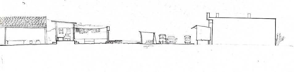
Hand drawn sections and plan for the stretch


Plan and Section of one of the houses showing different layers of spaces.
Narrative Drawing of the stretch:

Cross Sections of the street:


The website for this settlement study can be found here and the all drawings and archival material can be found on this link.